NOTE: I have finished processing the latest version of the TRMM products (v07). Since the same algorithms are now being run on TRMM PR and GPM 2Ku data, we can confidently compare the output data from the two satellites. In order to facilitate this, I have changed the v07 TRMM regions so that they match the GPM v07 regions (with the exception that they terminate at +/- 40 instead of +/-67 latitudes).
BATCH DOWNLOADING: You can use wget to download data quickly. For example if you want to download all the interpolated files from South America for August of 2005, you could use the following command. Don't forget the slash (/) at the end of the URL. And do not use brackets around your username and password.
wget --debug --tries=10 --http-user=[login] --http-password=[password] --no-host-directories -r --cut-dirs=1 -A nc4 https://trmm.atmos.washington.edu/v07/AFC/interp_data/2005/08/
This website provides access to the database of the sixteen year University of Washington study of the Tropical Rainfall Measuring Mission (TRMM) Precipitation Radar (PR) datasets. The data, methods and analysis are described in the review paper by Houze, Rasmussen, Zuluaga, and Brodzik (2015).
The products in this data base are derived from the 2APR version 7A orbital data products (v07). This data is accessible via the NASA STORM database.
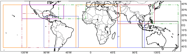
The data are stored by regions of the globe, represented by the boxes in the map above. By clicking inside a box on the map, the user will go to the page containing the analysis products for that selected region. One can accomplish the same thing by going here and clicking on the region of interest.
The NASA 2APR products are provided in bins along the slant range of the antenna beam. In the University of Washington database, these data in radar coordinates are geolocated and interpolated into a three-dimensional Cartesian grid and stored for analysis. From this dataset it is possible to identify structures of reflectivity echoes that satisfy certain criteria. Five types of echo objects are identified: shallow isolated echoes (SHI), deep convective cores (DCC), wide convective cores (WCC), deep-wide convective cores (DWC), and broad stratiform rain areas (BSR). Specific, defining characteristics of each of the objects are defined in section 5, below.
For all the classifications, the calculations are based on two different sets of thresholds - strong (str) and moderate (mod). Each object identified by these criteria is provided in netcdf format in both gridded (dimensioned by latitude and longitude) and tabular (dimensioned by instance or case) form. These gridded and tablular netcdf files contain information of the monthly climatology and individual properties of the identified echo objects. So, for example, the broad stratiform data from January of 2000 is contained in 4 files - strong thresholds and gridded, strong thresholds and tabular, moderate thresholds and gridded, and moderate thresholds and tabular.
Our echo feature products (SHI, DCC, WCC, DWC and BSR) and our corrected reflectivity fields are based on an interpolated dataset that we produce from the TRMM archived data identified as 2APR (specifially, the sub-product, attenuation corrected reflectivity). The TRMM archive provides these data in range bins along the slant range of the radar beam, i.e. in "radar coordinates." For each of the above-described regions, the 2APR data in each range bin are first geolocated and then interpolated into a regular three-dimensional Cartesian grid. The interpolated grid size is 0.05° (approximately 5 km) in the horizontal at 176 vertical levels (separated by 0.25 km) for the 2APR reflectivity factor. We remapped all data from 1998 to 2014 with the same horizontal resolution despite the change in orbital altitude of the TRMM satellite from 350 to 402 km in 2001, which changed the PR pixel size from 4.3 to about 5 km. Details of the methods applied for correcting the geolocation and the interpolation of the datasets can be found in Houze et al. (2007)
Additionally, nearest neighbor interpolation is used to re-grid the 2APR Near Surface Rain and Rain Type products corresponding to the selected areas into two-dimensional 0.05° grids. The interpolated netcdf files contain all of this information with appropriate meta-data containing accurate descriptions of the stored variables. Note that the files contain two versions of the interpolated Rain Type variable. One contains the original 2APR values (ranging from 100 to 313 and including values of -88 for no rain and -999 for missing data). The other has a simplified version of the categories assigning values of (1) for stratiform, (2) for convective, and (3) for other.
The UW database contains information on five (5) types of radar echo objects derived from the interpolated Cartesian data described above.
Mask fields have been added to the interpolated data files for each echo object and threshold. Each one is assigned a unique identifier (1, 2, 3, etc) that corresponds to the 'core_id' field in the tabular data files.
The file naming convention is consistent throughout the website. The files are stored in directories first by region and then by data type.
For the interpolated data, the convention is: [TRMMversion]_[UWversion]_[startDate].[startTime]_to_[endDate].[endTime]_[orbit]_[region].nc where
So a typical interpolated data filename might look like this - 'TRMM2APR7_uw4_20040701.021520_to_20040701.021618_037767_SAM.nc'. This file would contain interpolated data in netcdf format for 20040701 from 021520 to 021618 for the South America (SAM) region.
For the classified radar echo objects, the convention is: [TRMMversion]_[UWversion]_[classification]_[threshold]_[type]_[yyyymm]_[region].nc. where
So a typical filename might look like this - 'TRMM2APR7_uw4_BSR_mod_grd_199806_SAM.nc'. This file would contain broad stratiform (BSR) data based on moderate (mod) thresholds in 'gridded' format (grd) for June of 199806 for the South America (SAM) region.
Since our analyses started as a series of regional studies which eventually spanned most of the globe, the data is meant to overlap at the edges of all the global regions. It is suggested that if a user needs to combine information from two or more regions for a singular analysis, a careful 'stitching' of the data must be accomplished to avoid identifying overlapped echo elements multiple times.
Houze, R. A., Jr., D. C. Wilton, and B. F. Smull, 2007: Monsoon convection in the Himalayan region as seen by the TRMM Precipitation Radar. Quart. J. Roy. Meteor. Soc., 133, 1389-1411.
Houze, R. A., Jr., K. L. Rasmussen, M. D. Zuluaga, and S. R. Brodzik, 2015: The variable nature of convection in the tropics and subtropics: A legacy of 16 years of the Tropical Rainfall Measuring Mission (TRMM) satellite. Rev. Geophys., 53, 1-28, doi:10.1002/2015RG000488.
Erich Stocker of NASA/Goddard Spaceflight Center provided invaluable help with the processing of the data and products provided via this website.
In all publications and presentations based on the information
provided via this website, please acknowledge the University of Washington
with a statement like this: "Data for this study comes from the University of
Washington TRMM Data Set located at http:// trmm.atmos.washington.edu and
supported by the NASA Earth Sciences PMM Program".